

Revolutionary War Maps
The Library of Congress has a rich collection of historical maps of the Revolutionary War era. Many were created by British cartographers. A nice feature at the Library of Congress Website is the ability to zoom in on specific areas of the map. Examine the maps below. What are some of the interesting features of these early maps? How do they compare to the maps you see today?
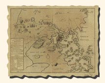 Click on the Map to View a Larger Image J. De Costa Courtesy of The Library of Congress |
A plan of the town and harbour of Boston and the country adjacent with the road from Boston to Concord, showing the place of the late engagement between the King's troops & the provincials, together with the several encampments of both armies in & about Boston. Taken from an actual survey. Humbly inscribed to Richd. Whitworth by J. De Costa; C. Hall, sc. |
| Boston, its environs and harbour, with the rebels works raised against that town in 1775, from the observations of Lieut. Page of His Majesty's Corps of Engineers, and from those of other gentlemen. |
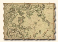 Click on the Map to View a Larger Image Thomas Hyde Page, Sir, 1746-1821 Courtesy of The Library of Congress |
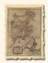 Click on the Map to View a Larger Image Robert Aitken, 1735-1802 Courtesy of The Library of Congress |
A new and correct plan of the town of Boston, and provincial camp. Engrav'd for the Pennsylva. magazine" v. 1, 1775, p. 29. Relief shown pictorially |
| Map illustrating the British attack at Lexington. |
 Click on the Map to View a Larger Image Russell & Struthers N.Y. Harper's New Monthly Magazine May, 1875 Courtesy of Cornell University Library |
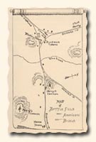 Click on the Map to View a Larger Image Souvenir of 1775 Lexington 1775-1875 E. G. Porter, James R. Osgood & Co., 1875 |
Map from a souvenir booklet commemorating the 100th anniversary of the Battle of Lexington, which opened the war for American independence. |
Updated March 5, 2017
© 2002 Rita Bigham. Linda C. Joseph, and Linda D. Resch
All Rights Reserved
