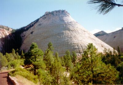
Nav Bar Home Curriculum Ideas Postcards Research Tools Treasure Hunts Web Links Web Projects Web Picks About

Cyberbee Gallery

Primary Source Collections


Home ::
Album list :: My Favorites :: Search
Home > National Parks > Zion National Park
Click to view full size image
Checkerboard Mesa
The name stems from the cliff s distinctive checkerboard pattern. The horizontal lines are caused by crossbedding, a remnant of ancient sand dunes. The vertical lines formed because of the contraction and expansion of the sandstone.

Zion National Park is located along the edge of a region known as the Colorado Plateau. The rock layers have been uplifted, tilted, and eroded, forming a feature called the Grand Staircase, a series of colorful cliffs stretching between Bryce Canyon and the Grand Canyon. The bottom layer of rock at Bryce Canyon is the top layer at Zion, and the bottom layer at Zion is the top layer at the Grand Canyon.

Source: National Park Service
0591.jpg 0592.jpg 0594.jpg 0595.jpg
File information
Filename:0595.jpg
Album name:admin / Zion National Park
Keywords:Zion Checkerboard Mesa
Photographer:Rosalind Noble
Date:1990
File Size:808 KB
Date added:Nov 18, 2009
Dimensions:965 x 673 pixels
Displayed:603 times
URL:http://www.cyberbee.com/imagegallery/displayimage.php?pos=-322
Favorites:Add to Favorites

Updated October 10, 2009
© 1996 - 2009 Linda C. Joseph
All Rights Reserved
All CyberBee Graphics are Trademarked

Graphics by
Darlene Vanasco/Creative Director
Erika Taguchi/Designer & Illustrator
Hosting Provided by Iwaynet