Nav Bar Home Curriculum Ideas Postcards Research Tools Treasure Hunts Web Links Web Projects Web Picks About

Cyberbee Gallery

Primary Source Collections


Home ::
Album list :: My Favorites :: Search
Home > National Parks > Antietam National Battlefield
Click to view full size image
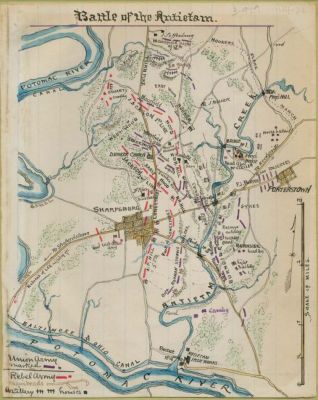
Battle of the Antietam
Conveys the placement of Union and Confederate forces in Washington County, Md., around Sharpsburg during the Battle of Antietam on September 17, 1862.

Robert Knox Sneden scrapbook (Mss5:7 Sn237:1), Virginia Historical Society.

In the Robert Knox Sneden diary, 1861-1865 (v. 3, p. 929).
Courtesy of The Library of Congress
00808.JPG 00811.JPG antietam_map.jpg antietam_map2.jpg antietam_map3.jpg
File information
Filename:antietam_map2.jpg
Album name:admin / Antietam National Battlefield
Keywords:Map Antietam
Date:[1861-1865]
File Size:143 KB
Date added:Oct 27, 2009
Dimensions:757 x 950 pixels
Displayed:750 times
URL:http://www.cyberbee.com/imagegallery/displayimage.php?pos=-38
Favorites:Add to Favorites

Updated October 10, 2009
© 1996 - 2009 Linda C. Joseph
All Rights Reserved
All CyberBee Graphics are Trademarked

Graphics by
Darlene Vanasco/Creative Director
Erika Taguchi/Designer & Illustrator
Hosting Provided by Iwaynet